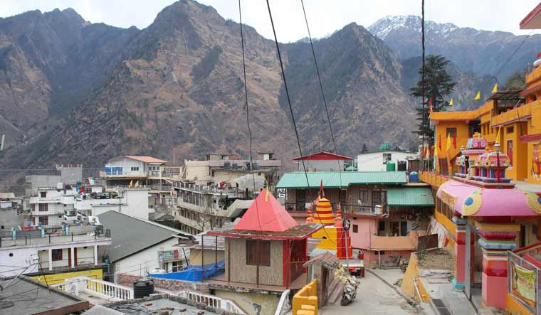
Winters in the more than 1,300-year-old ancient Himalayan town of Joshimath are dismally cold. But nowadays in the mountains, along with the cold there is a heavy air of despondency that is thick with rumours.
It all began about three months ago when locals began talking of cracks that began appearing suddenly in many buildings and the roads across the town. Officially, reports were recorded from about a month back. But the panic set in just about a week ago when the widening cracks spread and began appearing at a scary pace.
The creeping fear has now spread among residents in the nearby Himalayan towns including Karnaprayag, Munsiari, Dharchula, Pauri and Nainital and even Mussoorie.
Even as people from Joshimath’s around 90 ‘unsafe zones’ and more than 723 damaged houses have been evacuated to safer areas, concerns are also being raised about the safety of the key Indian Army’s cantonment and ITBP establishments in the town.
These two military and security set-ups are of critical importance when it comes to sending reinforcements and supplies to the Line of Actual Control, the de facto border with an increasingly assertive China.
Locals also talk of ‘quiet’ explosions by corporates and builders to clear land for construction. Refusing to be named, a government official told THE WEEK: “All construction activity in the town is resorting to silent and muffled explosions. It has become an accepted practice.”
There has also been public chatter blaming tunneling work by the National Thermal Power Corporation (NTPC) Tapovan Vishnugad project and the construction of the Halong-Marwari bypass project by the Border Road Organisation (BRO) for the state of affairs.
With the raging crisis threatening to assume the form of a widening public protest demanding adequate compensation, rehabilitation, stopping construction and ongoing demolition work in Joshimath, fingers are also being pointed at the controversial Char Dham road project and the Rs 16,216 crore rail project to link the four major pilgrimages—Kedarnath, Badrinath, Gangotri and Yamunotri. But various sources corroborate that it has been common knowledge that the Joshimath town had been sinking for decades but at the moment the pace has become frenetic.
There have been prophetic revelations from the past too. About 87 years ago, a Swiss expedition of mountain geologists led by Arnold Heim and August Gansser opened up the Kumaon mountains to the rest of the world about the geology of the region. It was the first study to establish that Joshimath lay not on a hard rock basement but on sand and loose soil that was the remnant of an ancient landslide.
The duo had prepared a 284-page report titled “Central Himalaya: Geological Observations of the Swiss Expedition 1936”. Dressed in jargon, their findings had an ominous ring as they described the region in and around Joshimath and especially the Kuari Pass, situated less than 5 km aerial distance south from Joshimath and a favourite with trekkers because of the scenic views it offers.
“The largest and longest landslide has its origin on the mountain crest at 4,000 metres, east of the Kuari Pass. We shall call it the Kuari Slip. The length from South to North is 8-10 kilometers, the width up to 3 kilometers. The average thickness being estimated at 150 meters, the volume would be about 2,3 cubic kilometers… Joshimath is situated on a slope of blocks which extends 5 kilometer to the South East,” the report pointed out.
Even in 1936, the Kuari Slip was partly covered with fir timber and in places was cultivated and inhabited. Several small villages were situated on the stream of scree. “It further seems that there is a moraine below the slided material. The whole appearance is that of a pre-historic and perhaps inter-glacial slide,” the report added.
Says Prof SP Singh, former vice chancellor of HNB Garhwal University: “There was no shortage of warnings. The Swiss report first issued the warning in 1936. Earlier Uttar Kashi, Nainital faced problems. It is a fait accompli now. The deed has been done.”
“All Himalayan towns are under the wheels of vehicles. Thoughtless and unregulated development in the delicate region without foresight and proper planning has led to this state of affairs. One can only try to alleviate the misery now which will bear a huge cost,” says Prof Singh, who has studied the Himalayan ecology for more than four decades.
Four decades after the Swiss study, the collector of Garwal MC Mishra was commissioned to probe as to why Joshimath was subsiding. The 1976 report was blatant in its findings. It said Joshimath wasn’t suited to be an urban centre because of its weak foundation and that conditions will only worsen with growing population, increasing construction works, rising traffic and importantly, lack of a sewerage system which led the water discharge into the ground further loosening the foundation on which the town stood.
Joshimath stands at the gateway to quite a few top Hindu and Sikh pilgrimages in the Himalayas. Growing from a quant sleepy hamlet providing shelter to pilgrims to a bustling town of more than 20,000 now, the rate of increase of population pressure it has been facing is mind-boggling.
In 1936, between 50,000 and 100,000 pilgrims hit this trail every year. Cut to 2022, about 10,00,00,000 tourists, the devout and kanwarias—according to a rough estimate—used this route.


