Satellite observations have recorded that Joshimath has been sinking for the last four years.
While a government ban on government bodies and experts speaking on the Joshimath disaster has frustrated many, it can now be concluded that it was a disaster long in the making, with information available in the public domain.
Satellite observations of the Copernicus Sentinel Programme (a cooperative mission developed in partnership between Europe and the USA) detect, among other parameters, surface motion. This helps in computing displacement over a broad region.
Imagery from the programme, picked up from 150 scenes in the region, from January 2018 to December 31, 2022, have allowed the measurement of displacement velocities and corresponding time series from stable points on the ground, such as buildings, metallic objects, and bare rocks. This measurement is accurate to millimetre level.
While displacement is a measure of the starting and ending positions of an object, velocity is the rate at which the displacement takes place.
A post on the Geohazards Exploitation Platform, culled from satellite data, said “clear deformation signal is visible at the town of Joshimath as well as on the opposite slopes, while the rest of the region seems relatively stable.”
There are four distinct displacement patterns available. The eastern part of the slope exhibits a displacement of 10cm a year while the western part is slightly less. The area between these two active zones showed small displacement till the end of 2021 and then started to accelerate. The upper western part also shows constant progressive acceleration.
In December 2022, the displacement became most pronounced.
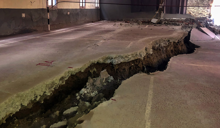
“It is also in agreement with recent field observations mentioning the opening of fissures of several centimeters testifying of a complex sliding pattern with both vertical and horizontal deformation”, reads the post which is the result of a cooperation between the Aristotle University of Thessaloniki and the Ecole et Observatoire des Sciences de la Terre (The School of Observatory and Earth Sciences, Strasburg, France).
Dave Petley, Vice-Chancellor of the University of Hull, UK, who provides commentary and analysis of landslide events occurring worldwide, has, meanwhile, questioned the wisdom of unnamed experts, quoted by the Indian media.
Petley pointed to assertions that as soon as the summer starts, there will be a “positive change” in the situation. He writes, “This is slightly odd. First, the summer is a long way hence, and second, the summer will bring monsoon rainfall, which is unlikely to help (although it will not necessarily have an adverse effect). Finally, of course, the land is not trying to do anything except obey the laws of physics”.
Pointing to the above-mentioned analysis made possible by Sentinel 1 imagery, Petley writes, “This diagram clearly shows the various landslide units upon which the town is built, and the movement patterns that they display in the long term. It confirms that the deformation is sliding, not subsidence, as expected”.
The time series for displacement shows the landslide complex are moving at different rates. The greatest displacement is almost half a metre with continuous creep that fluctuates with time.
Creep is the imperceptibly slow, steady, downward movement of slope-forming soil or rock. Movement is caused by shear stress sufficient to produce permanent deformation, but too small to produce shear failure. Creeps can be seasonal, continuous or progressive.
Shear refers to change of shape- caused by forces acting in opposite directions.
“Movement of landslide complexes such as this is very complex, and we would expect changes in the rate occurring through time. Thus, great care is going to be needed in interpreting short duration time series data. But, the bottom line is that this slope is unlikely to achieve permanent stability in its current physical state without significant engineering intervention. The current crisis will abate at some point, but the underlying chronic problem, whatever the cause, is likely to remain. That is not to say that all is lost by any means, the immediate crisis will pass, but action is likely to be needed”, writes Petley.
Publicly available satellite imagery shows Joshimath has been sinking for 4 years
There are four distinct displacement patterns observed
 Cracks appear in a badminton court due to landslides, in Joshimath of Uttarakhand | PTI
TAGS
📣 The Week is now on Telegram. Click here to join our channel (@TheWeekmagazine) and stay updated with the latest headlines
Read more
*Articles appearing as INFOCUS/THE WEEK FOCUS are marketing initiatives


